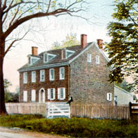
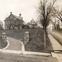
“Margaret Long and her son, Clarence, collect seven cents toll from driver of this super-deluxe 1910 French car with right-hand drive.” —Victoria Donohoe. The photo shows Montgomery Avenue at Meeting House Lane looking west; the 1803 Price house (714 Montgomery) can be seen behind the vehicle.
Tollkeepers of Narberth
The Main Line Chronicle identified this tollgate as the only one with a resident keeper, "kept for years by Mrs. Margaret Miller. The position was later held for seven or eight years by Mrs. Long". In the 1900 census, that was John and Margaret Miller, in 1910 Margaret Long, counted inaccurately in Lower Merion, not Narberth.
 It isn't often we can date a century-old image to an exact year. Here the car's dealer license plate tells us it's 1910, confirming we're seeing Margaret Long.
Toll Roads of the Main Line
A. H. Mueller's 1908 and 1913 property atlases locate this as the fourth tollgate out of Philadelphia; others are mapped at 54th and City Line, Bala and Montgomery Aves., Levering Mill Rd. and Montgomery Ave., and, further out, Church Rd., Ardmore.

The toll house, pictured here in its last years of operation, was part of a practice that had existed in America since the 1790s, of private road ownership with maintenance financed by tolls. Montgomery Avenue was controlled by the Philadelphia, Bala and Bryn Mawr Turnpike Company. It used to be known as Old Lancaster Road, "old" after the Philadelphia and Lancaster Turnpike (Lancaster Pike) opened in 1794 as the first engineered toll road in the nation.
Three extant Old Lancaster Road sections, in Merion, Haveford and Bryn Mawr, link present-day Montgomery Ave. and Conestoga Road as "The Lancaster Road", visible on the 1777 layer of the Narberth History Map. Before that, they were part of the Allegheny Path, "the oldest road in Pennsylvania which passed between the Delaware and the Susquehanna", an Indian trail before it was a colonial road.


In 1876 the Pennsylvania Railroad bought the Lancaster Turnpike from 52nd street to Paoli for $20,000 to suppress competition from streetcar lines. In 1913 the state bought both toll roads, in 1917 made them free, and within the next decade Lancaster Pike was incorporated into the new national highway system.

All the toll houses were put up for auction with the stipulation that the winning bidders remove them by January 1, 1918. This toll house on Montgomery Avenue across from Merion Meeting House was moved to its present location at 346 Meeting House Lane in Narberth.

Transcription
LANCASTER PIKE IS FREE
The Lancaster pike, from Overbrook to Paoli, was freed from tolls on Monday one day late. Joseph W. Hunter, Deputy Commissioner of State Highways, and John S. G. Dunne, superintendent of the turnpike company, traveled along the famous old roadway shortly after noon in an automobile and closed all the toll houses—nine of them.
The tollgate keepers packed up and quit, and as soon as possible the old houses, some of which are used as dwellings by the keepers, and the little sentry boxes guarding the side roads, will be removed.
It was a distinct surprise to the motorists, as previous reports had indicated that the closing would be delayed for some days, and for hours automobilists were slowing up at the deserted posts of the tollgate keepers to pay their way, only to brighten up and speed away joyously when the news broke upon them.

Bryn Mawr Home News September 14, 1917
Transcription
Toll Houses at Public Sale
The Toll Houses on the Line of the Lancaster Turnpike Road from the Philadelphia City Line to Paoli, recently purchased by the State, will be sold at Public Sale on
Tuesday, October 2nd, 1917
The Sale will commence at the toll house at or near City Line at One o’clock P.M., and will be proceeded with until the last toll house at St Davids is disposed of.
Each toll house contains six rooms and is in fair condition. They will be sold on the following terms: — The highest bidder to be the purchaser. The purchase money to be paid in cash at the time of sale. Each toll house must be removed by the purchaser thereof from off the right of way of said turnpike road on or before January 1st, 1918. Any toll house not so removed will be removed by the Department and the material disposed of to pay the costs of such removal.
By Order of The State Highway Commissioner, WARREN F. CRESSMAN, Assistant Engineer.
References
Paul A.W. Wallace, Indian Paths of Pennsylvania (1965), quoting John T. Faris, Old Trails and Roads in Penn's Land (1927). Return
Photos of Montgomery Pike toll houses appear in The First 300 (Lower Merion Historical Society, 2000).
Updated July 18, 2025.


